
PROGRESS OF APPLICATION OF P-CABLE SYSTEM OF 3-D HIGH-RESOLUTION SEISMIC
-
摘要: 高分辨率三维海洋反射地震P-cable系统已经成功应用在海底天然气水合物、储层填图和海底灾害的研究中,特别是针对海底气烟囱和泥火山等小目标体的内部结构和空间分布特征的研究。在海底大洋钻探的目标区,P-cable系统能够提供准确的高分辨率的三维地震数据,有利于海底大洋钻探的井位选取和井位钻探时间评估。与常规的工业界使用的长电缆三维海洋反射地震比较,高分辨三维海洋反射地震P-cable系统具有简单、高效和经济实用性的优点,能够更加高效、快捷地为科研人员开展海洋地质和地球物理的研究工作,有助于为今后我国在深潜方面发现的海底“烟囱”开展详细地下高分辨率的三维地震结构调查,成为深潜方面的一个补充和一个强有力的海洋填图工具。依据实例分析并讨论了高分辨的三维海洋地震P-cable系统在海底气烟囱和泥火山内部结构以及空间分布特征方面的应用和科学研究。建议今后在海洋地球物理调查中开展高分辨的三维海洋反射地震调查和研究,特别针对广阔海域陆坡区天然气水合物、海底泥火山和气烟囱以及海底滑坡灾害方面开展更为精细的三维海洋反射地震调查和相关科学问题的研究工作。
-
关键词:
- 三维海洋反射地震P-cable系统 /
- 高分辨率 /
- 气烟囱 /
- 泥火山 /
- 天然气水合物
Abstract: The P-cable system of high-resolution 3-D seismic has been successfully applied to the researches of submarine gas hydrate, reservoir mapping and seafloor geohazards, especially to the internal structure and spatial distribution patterns of small targets such as seafloor gas chimneys and mud volcanoes. The P-cable system can also provide accurate high-resolution 3-D seismic data for ocean drilling site survey, especially for site selection and drilling time estimation. Comparing to the long streamer 3-D seismic survey commonly used by the industry, the P-cable system of high-resolution 3-D seismic is more flexible and easy to users. It is simple, fast and economic to marine geological and geophysical researches. The detailed description of 3-D structures of seafloor gas chimneys, which is usually done by deep diving, can be made by the P-cable system as well and thus the P-cable system of high-resolution 3-D seismic may be used as a supplement to deep diving and a strong seafloor mapping tool in the future. In this paper, we presented some real cases on the application of the system to the internal structures description of seafloor gas chimneys and mud volcanoes and their spatial distributions. We suggest that the P-cable system of high-resolution 3-D seismic be applied more often in the future to marine geophysical survey, specially to fine marine seismic investigation and associated scientific researches related to submarine gas chimneys, seafloor mud volcanoes and slumping slides in the areas of continental slope.-
Keywords:
- 3-D seismic P-cable system /
- high resolution /
- gas chimneys /
- mud volcanoes /
- gas hydrate
-
-
![]()
![]()
![]()
图 3 海底气烟囱结构图
(据文献[9]) a.区域A的海底振幅和测线位置图;b.连续不同地震测线显示的气烟囱结构变化;c.不同地震时间切片图,数字显示的不同层位;d.地震交叉测线显示的气烟囱结构图
Figure 3. Internal structure of a gas chimney
(modified after[9]) a. Seafloor amplitude map of area A showing location of seismic lines; b. Structure of gas chimneys along different continuous seismic lines; c. Time-slice map of different seismic times, number 1, 2, 3 and 4 represent the different levels; d. Structure of a gas chimney along crossing seismic lines
![]()
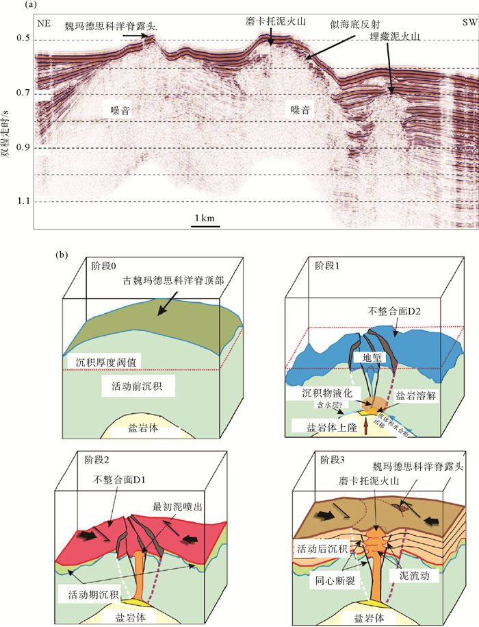
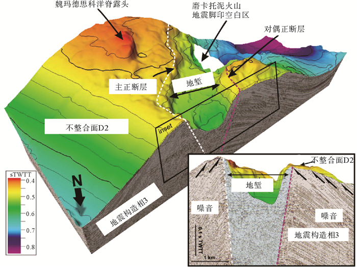
图 4 海底泥火山地震和地质解释结构图
(据文献[27]) a. P-cable系统采集并抽取的二维地震反射剖面,清晰展示了磨卡托泥火山(MMV)和一个埋藏泥火山(BMV);b.泥火山形成和演化模式图
Figure 4. Seismic signature of a mud volcano and geological interpretation
(modified after[27]) a. An inline seismic profile extracted from 3-D seismic block by the P-cable system, MMV and BMV are imaged on the seismic profile, b. Formation and evolution of mud volcanoes
![]()
表 1 不同类型的三维海洋地震采集设备和分辨率特征(据文献[13])
Table 1 3-D marine seismic acquisition devices and their resolution (data from reference[13])
序号 名称 震源和频率范围 接收 分辨率 目标区域 1 3D CHIRP 调频声呐1.5~13 kHz 11条电缆@25 cm间距6道@25 cm间距 ∠10 cm 100s×100s m2 10s m 2 SEANAP 3D 布黙4.5 kHz 8条电缆@50 cm间距4道@50 cm间距 10 cm 100s×100s m2 10s m 3 OPU3D 布黙2 kHz 8条电缆@2 m间距2道@2 m间距 20 cm 100s×100s m2 10s m 4 VHR3D 电火花(250 J) 500 Hz 4条电缆@4 m间距6道@2 m间距 75 cm several km2 10s m 5 3D 单一微型气枪300 Hz 3条电缆@7.5 m间距24道@2.5 m间距 1.2 m several km2 100s m 6 HR3D 2组微型气枪阵110 Hz 2条电缆@25 m间距24道@6 m间距 3.5 m 10 s km2 100s m 7 P-cable 2组气枪阵90 Hz 12条电缆@12.5 m间距8-16道@6.25 m间距 4 m 10s km2 100s m 8 R/V Langseth 2组气枪阵50 Hz 4条电缆@150 m间距468道@12.5 m间距 7.5 m 100s km2 1 000s m 注:本表列举的是非工业界的海洋三维地震采集参数。  下载: 导出CSV
-
[1] Bangs N L B, Hornbach M J, Berndt C. The mechanics of intermittent methane venting at South Hydrate Ridge inferred from 4D seismic surveying[J]. Earth and Planetary Science Letters, 2011, 310(1-2): 105-112. doi: 10.1016/j.epsl.2011.06.022
[2] Marsset T, Marsset B, Thomas Y, et al. Very high resolution 3D seismic: a new imaging tool for sub-bottom profiling[J]. Comptes Rendus Geoscience, 2002, 334(6): 403-408. doi: 10.1016/S1631-0713(02)01766-2
[3] Marsset T, Marsset B, Thomas Y, et al. Analysis of Holocene sedimentary features on the Adriatic shelf from 3D very high-resolution seismic data (Triad survey)[J]. Marine Geology, 2004, 213(1-4): 73-89. doi: 10.1016/j.margeo.2004.10.002
[4] Missiaen T. VHR marine 3D seismics for shallow water investigations: some practical guidelines[J]. Marine Geophysical Researches, 2005, 26(2-4): 145-155. doi: 10.1007/s11001-005-3708-7
[5] Scheidhauer M, Marillier F, Dupuy D. Development of a system for 3D high-resolution seismic reflection profiling on lakes[J]. Marine Geophysical Researches, 2005, 26(2-4): 183-195. doi: 10.1007/s11001-005-3717-6
[6] Gutowski M, Bull J M, Dix J K, et al. Three-dimensional high-resolution acoustic imaging of the sub-seabed[J]. Applied Acoustics, 2008, 69(5): 412-421. doi: 10.1016/j.apacoust.2006.08.013
[7] Vardy M E, Dix J K, Henstock T J, et al. Decimeter-resolution 3D seismic volume in shallow water: a case study in small-object detection[J]. Geophysics, 2008, 73(2): B33-B40. doi: 10.1190/1.2829389
[8] Mutter J C, Carbotte S, Nedimovic M, et al. Seismic imaging in three dimensions on the East Pacific Rise[J]. EOS, 2009, 90(42): 374-375. doi: 10.1029/2009EO420002
[9] Petersen C J, Bünz S, Hustoft S, et al. High-resolution P-Cable 3D seismic imaging of gas chimney structures in gas hydrated sediments of an Arctic sediment drift[J]. Marine and Petroleum Geology, 2010, 27(9): 1981-1994. doi: 10.1016/j.marpetgeo.2010.06.006
[10] Vardy M E, Bull J M, Dix J K, et al. The geological Hubble: a reappraisal for shallow water[J]. The Leading Edge, 2011, 30(2): 154-159.
[11] Moore G F, Bangs N L, Taira A, et al. Three-dimensional splay fault geometry and implications for Tsunami generation[J]. Science, 2007, 318(5853): 1128-1131. doi: 10.1126/science.1147195
[12] Thomas Y, Marsset B, Westbrook G K, et al. Contribution of high-resolution 3D seismic near-seafloor imaging to reservoir-scale studies: application to the active North Anatolian Fault, Sea of Marmara[J]. Near Surface Geophysics, 2012, 10(4): 291-300. doi: 10.3997/1873-0604.2012019
[13] Planke S, Berndt C. Apparatus for seismic measurements: US, 7221620 B2[P]. 2007-05-22.
[14] Planke S, Eriksen N, Berndt C, et al. P-cable high-resolution seismic[J]. Oceanography, 2009, 22(1): 81. http://d.old.wanfangdata.com.cn/NSTLQK/NSTL_QKJJ0217095610/
[15] Ebuna D, Mitchell T J, Hogan P J, et al. High-resolution offshore 3D seismic geophysical studies of infrastructure geohazards[C]//Symposium on the Application of Geophysics to Engineering and Environmental Problems (SAGEEP). Denver, Colorado USA: Environment and Engineering Geophysical Society, 2013: 311-320.
[16] Geometrics. GeoEel Solid Streamer[C]. San Jose, California USA: Geometrics, Inc., 2012, http://www.geometrics.com/files/geoeelsolid.pdf.
[17] Eriksen O K, Berndt C, Büenz S, et al. Styles of shallow gas migration and accumulation on the Norwegian continental margin[C]//73rd EAGE Conference & Exhibition Incorporating SPE EUROPEC 2011. Vienna, Austria: SPE, 2011.
[18] Berndt C, Costa S, Canals M, et al. Repeated slope failure linked to fluid migration: the Ana submarine landslide complex, Eivissa Channel, Western Mediterranean Sea[J]. Earth and Planetary Science Letters, 2012, 319-320: 65-74. doi: 10.1016/j.epsl.2011.11.045
[19] Kvenvolden K. Gas hydrates-geological perspective and global change[J]. Review of Geophysics, 1993, 31(2): 173-187. doi: 10.1029/93rg00268
[20] Plaza-Faverola A, Bünz S, Mienert J. Repeated fluid expulsion through sub-seabed chimneys offshore Norway in response to glacial cycles[J]. Earth and Planetary Science Letters, 2011, 305(3-4): 297-308. doi: 10.1016/j.epsl.2011.03.001
[21] Hornbach M, Bangs N, Berndt C. Detecting hydrate and fluid flow from bottom simulating reflector depth anomalies[J]. Geology, 2012, 40(3): 227-230. doi: 10.1130/G32635.1
[22] Karstens J, Berndt C. Seismic chimneys in the Southern Viking Graben-implications for palaeo fluid migration and overpressure evolution[J]. Earth and Planetary Science Letters, 2015, 412: 88-100. doi: 10.1016/j.epsl.2014.12.017
[23] Vogt P R, Crane K, Sundvor E, et al. Methane-generated (?) pockmarks on young, thickly sedimented oceanic crust in the Arctic: Vestnesa Ridge, Fram Strait[J]. Geology, 1994, 22(3): 255-258. doi: 10.1130/0091-7613(1994)022<0255:MGPOYT>2.3.CO;2
[24] Vogt P R, Gardner J, Crane K, et al. Ground-truthing 11- to 12-kHz side-scan sonar imagery in the Norwegia-Greenland Sea: Part Ⅰ: pockmarks on the Vestnesa Ridge and Storegga slide margin[J]. Geo-Marine Letters, 1999, 19(1-2): 97-110. doi: 10.1007/s003670050098
[25] Hustoft S, Bünz S, Mienert J, et al. Gas hydrate reservoir and active methane-venting province in sediments on ∠20 Ma young oceanic crust in the Fram Strait, offshore NW-Svalbard[J]. Earth and Planetary Science Letters, 2009, 284(1-2): 12-24. doi: 10.1016/j.epsl.2009.03.038
[26] Judd A, Hovland M. Seabed Fluid Flow: The Impact on Geology, Biology and the Marine Environment[M]. Cambridge: Cambridge University Press, 2009: 475.
[27] Perez-Garcia C, Berndt C, Klaeschen D, et al. Linked Halokinesis and mud volcanism at the Mercator mud volcano, Gulf of Cadiz[J]. Journal of Geophysical Research, 2011, 116(B5): B05101, doi: 10.1029/2010JB008061.
[28] Van Rensbergen P, Depreiter D, Ivanov M K, et al. El Araiche mud volcano field[M]//Kenyon N H, Ivanov M K, Akhmetzhanov A M, et al. Interdisciplinary Geoscience Research on the North East Atlantic Margin, Mediterranean Sea and Mid-Atlantic Ridge[M]. Paris: Intergovernmental Oceanographic Commission, 2003, 67: 43-51.
[29] Van Rensbergen P, Depreiter D, Pannemans B, et al. The El Arraiche mud volcano field at the Moroccan Atlantic slope, Gulf of Cadiz[J]. Marine Geology, 2005, 219(1): 1-17. doi: 10.1016/j.margeo.2005.04.007
[30] Van Rensbergen P, Depreiter D, Pannemans B, et al. Seafloor expression of sediment extrusion and intrusion at the El Arraiche mud volcano field, Gulf of Cadiz[J]. Journal of Geophysical Research, 2005, 110(F2): F02010, doi: 10.1029/2004JF000165.

计量
- 文章访问数: 3065
- HTML全文浏览量: 806
- PDF下载量: 35
