Distribution and Migration Pattern of Surficial Suspended Matter in Zhejiang and Fujian Mud Area Detected by Landsat Satellite Images
-
摘要: 基于2007年2月和2015年6月的东海悬浮体浓度数据,分别对2007年2月、7月的Landsat Thematic Mapper(Landsat-TM)和2014年12月、2015年6月Landsat Operational Land Imager(Landsat-OLI)卫星影像建立表层悬浮体浓度反演模型,发现建立的指数函数模型反演效果最佳,相关系数分别为0.971和0.856,其可以反映冬夏两季表层悬浮体分布特征及其控制作用。研究发现,浙闽沿岸海域表层悬浮体浓度呈近岸高远岸低、冬季高夏季低的特点;冬季浙闽沿岸流携带的表层悬浮体浓度范围为10~28 mg/L,台湾暖流为1.5~5 mg/L;夏季浙闽沿岸流携带的表层悬浮体浓度范围为4~22 mg/L,台湾暖流为1.2~2.3 mg/L。并且在冬季发现在40 m水深海域存在较明显的表层悬浮体浓度次级锋面及一系列涡旋,而夏季不明显,推测冬季悬浮体对现代浙闽涡旋泥质区形成有所贡献。Abstract: Inversion models of SSC are established based on the observed suspended sediment concentration (SSC) in the East China Sea in February 2007 and June 2015, in combination with the satellite images. It is found that the exponential inversion model is the best in use. The squared correlation coefficient is 0.971 and 0.856 for 2007 and 2015 respectively. The results may well suggest the distribution pattern and control factors of the suspended sediment. It is also found that the near shore SSC is stronger than offshore one, and the winter one is higher than that in summer. In winter, the SSC ranges 10~28 mg/L in the Zhejiang and Fujian Coastal Current and 1.5~5 mg/L in the Taiwan warm current. In summer, however, the SSC ranges 4~22 mg/L in the Zhejiang and Fujian Coastal Current and 1.2~2.3 mg/L in the Taiwan warm current. A SSC secondary front was found in the research in addition to the vortices found in the 40 m water depth in winter. However, the SSC secondary front and vortices are not so obvious in summer. According to the result, the winter suspended sediment may contribute more to the formation of the Modern Zhejiang and Fujian vortex mud area.
-
表层悬浮体(粒径大于10-7m,悬浮于0.5 m至水面的水深范围内的固体颗粒[1])的含量是近岸水体中最重要的水质参数之一,其浓度的高低不仅影响着水体浑浊度和水色等光学信息,也影响着近岸生态环境和近岸带沖淤演变过程。因此,探究表层悬浮体含量的变化对近岸带水质、生态、环境的研究以及海岸工程、港口建设都有极其重要的意义[2, 3]。
在海洋水色遥感中,一般将水体分为Ⅰ类和Ⅱ类水体。Ⅰ类水体即大洋开阔水体;Ⅱ类水体的光学性质主要由悬浮物质、浮游植物和可溶性有机物决定,即近岸水体和受陆源物质影响强烈的河口水体[4]。监测Ⅱ类水体表层悬浮体浓度(SSC, Suspended Sediment Concentration)及其变化是研究悬浮体运移的基础,传统的悬浮体浓度测量是走航式定点站位采样、分析,其优点是精度较高,但调查速度慢、周期长、费用高,而且只能获取在时间、空间上都离散的点数据,效率低;与传统的测量方式相比,卫星遥感技术具有大范围瞬时同步的特点,具有空间、时间上的连续性,其覆盖范围广,重复性好,能有效地监测水体中水深5 m以内的表层海水悬浮体含量的变化[5],极大地提高效率,因此水色遥感技术在大面积海域的表层悬浮体监测中具有不可代替的优势。
目前国内外学者利用卫星影像数据与实测资料相结合,建立了许多定量及半定量的反演模型,使用较多的是建立悬浮体浓度与水体光学性质之间的定量关系模型。将所选择的遥感参数与悬浮体浓度进行回归分析,分别运用线性函数、多项式函数、指数函数、幂函数等经验模型对所选取的遥感参数和表层悬浮体浓度进行拟合,选取出实测值与反演值拟合效果最佳的函数模型作为表层悬浮体浓度定量反演模型[6]。Gordon等[7]利用可见光波段建立对数模型在表层悬浮体浓度较高的水体中反演效果较好;TASSAN[8]基于Landsat-TM卫星数据提出的三分量模型对那不勒斯海近岸水体表层悬浮体浓度进行了观测;Wang等[9]利用Landsat-ETM+的850 nm的近红外波段直接建立了线性关系模型用于估算长江中上游表层悬浮体含量;Zhou等[10]基于Landsat-TM数据建立了多元回归模型在太湖表层悬浮体浓度反演中取得了较好结果。Cai等[11]综合利用Landsat-TM和Landsat-OLI的近红外波段建立的线性模型在杭州湾表层泥沙反演中效果较好。前人通过测定不同悬浮物浓度的反射率表明:在630~900 nm波段,水体反射率随悬浮物含量的增加而单调增加,适合用来监测表层悬浮体浓度的变化。然而由于缺乏足够的同步实测资料,只是利用一个时相数据确定SSC的定量反演模型,具有一定的偶然性,且遥感反演模型具有地域性差异及悬浮体浓度性差异特征,模型很难具有普遍的适用性。
海水表层温度(SST, Sea Surface Temperature)分布是海水热量传递的体现,在温度变化大的海域,一般对应着不同水团的交界或是水体流速的切变区。因此,SST的分布特征可以反映海水的流动情况,用以研究流系。对于SST的反演,覃志豪等[12]利用Landsat-TM第6波段依据地表热辐射传导方程推导出的反演算法对SST进行了精度较高的反演,其反演精度可以达到1.1℃左右;之后Jiménez-Muñoz等[13]对于Landsat-TM数据建立地表辐射率、大气透射率等参数与大气水汽含量之间的函数关系提出了一种仅有大气水汽含量一个未知参数的SST反演方法;现阶段,USGS认可了由Jiménez-Muñoz等[14]利用Landsat 8热红外波段(Thermal Infrared Sensor, 波段10与波段11)的劈窗算法来实现SST反演。本文采用中心波长为650 nm的红色波段和850 nm的近红外波段作为遥感参数来反演该区域的表层悬浮物浓度变化,采用TM 6、TIRS 10和TIRS 11的热红外波段反演SST变化。
浙闽沿岸流是东南沿岸的主要流系之一,由长江冲淡水以及浙闽沿岸入海河流共同形成,其温度和流向随着季节变化而不同,盐度较低;台湾暖流是出现在浙闽近海具有高温、高盐“洁净”的流动水体,一般沿50~100 m等深线向东北流动[15]。浙闽沿岸流和台湾暖流的分布、变化及相互作用共同控制着浙闽海域的水团分布、环流结构以及悬浮体的运移[16]。尤其是冬季,东北流向的台湾暖流与在冬季风作用下沿着近岸西南流向的浙闽沿岸流相遇,由于温度与盐度的显著差异形成强烈的锋面,抑制了悬浮体向外海的输运,同时部分黑潮水向内陆架入侵,加入到台湾暖流,共同影响浙闽海域的海流体系[17, 18]。
1. 数据与方法
1.1 区域概况与资料来源
研究区域位于26.1°~29.7°N、120°~123.6°E,又称浙闽沿岸海域,其海岸线较为曲折,地形复杂,沿岸港湾众多,主要港湾有杭州湾、象山港、三门湾、温州湾、乐清湾等,均属于强潮海区[19]。注入该海域的河流主要有钱塘江、椒江、瓯江、闽江等。海域悬浮体颗粒的来源,除去大部分来源于长江注入东海的陆源物质外,中小河流的贡献也不容忽视。悬浮体的分布及输运受到东海环流、风暴和潮流等的影响,受台湾暖流的阻隔作用,冬季和夏季长江入海泥沙在东海难以越过124°E以东海域[20]。
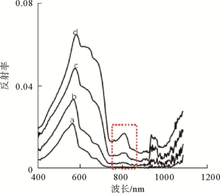
本文所采用的数据主要来源于2007年2月份的“东方红2号”调查船获得的29个站位观测资料及2015年6月20—24号“科学三号”考察船获得的21个站位观测资料。走航船沿岸线法向布设断面并跨越了东海内陆架泥质区,根据国家海洋局GB/T 12763.1-2007《海洋调查规范》中关于标准水层的相关规定,依次对站位表层水进行取样,在室内抽滤测定悬浮体质量浓度。考虑到研究区海域呈现狭长的特点,中低分辨率遥感影像像元尺度较大,在河口及岛屿附近可能会导致混合像元的出现,从而降低了反演精度。因此,需要基于高空间分辨率的遥感影像来构建研究区表层悬浮体浓度的估算模型。本文选取6景空间分辨率为30 m的Landsat-TM卫星影像(http://glovis.usgs.gov/下载)作为2007年SSC反演模型基础;选取6景涵盖波段更多、波段划分更为精细的Landsat-OLI影像作为2015年SSC反演模型基础。卫星过境时间与采样的时间差在原理上是可接受的,同时考虑到云的影响,选取了云量较少的影像;对2007年2月、7月的各6景Landsat-TM影像,2014年12月、2015年6月的各6景Landsat-OLI影像进行反演(表 1)。通过ENVI 5.1依次对影像进行几何校正、辐射校正、Flaash大气校正、去云等预处理。如图(图 2)所示,含沙水体的反射光谱存在两个峰值:550 nm的主峰和800 nm的次级峰,随着水体中悬浮物浓度的增大,可见光对水体透射能力减弱,反射能力加强,反射光谱的反射峰出现从短波向长波位移的现象,说明红光波段和近红外波段受水体中表层悬浮体浓度变化的影响较敏感。
表 1 影像编号及获取时间信息Table 1. Image number and time informationTM OLI 编号 获取时间 编号 获取时间 117040-117042 2007-02-11 117040-117042 2015-06-25 118040-118042 2007-02-02 118040-118042 2015-06-16 117040-117042 2007-07-22 117040-117042 2014-12-31 118040-118042 2007-07-28 118040-118042 2014-12-22 1.2 Landsat-TM反演SSC
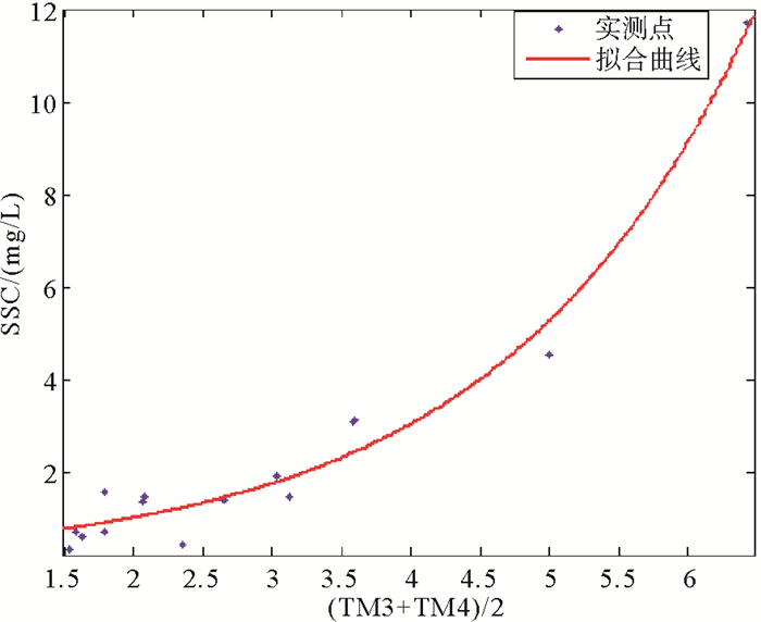
本文中Landsat-TM卫星影像选取对悬浮体浓度最为敏感的650 nm的红色波段(TM3)和能消除大气作用同时对悬浮体浓度较为敏感的850 nm的近红外波段(TM4)进行组合,作为反演水体表层悬浮体浓度的遥感参数:L=(TM3+TM4)/2[21],去除明显错误数据后,利用MATLAB对实测数据和所选取的遥感参数分别以线性函数模型、多项式函数模型、指数函数模型、幂指数函数模型等进行统计分析,发现指数模型的相关系数:R2=0.971,均方根误差:RMSE=0.505 1 mg/L;幂指数的相关系数:R2=0.949,RMSE=0.669 5 mg/L;多项式模型的相关系数:R2=0.951,RMSE=0.631 4 mg/L;线性模型的相关系数:R2=0.839,RMSE=0.827 3 mg/L;表明指数模型的拟合程度最高(图 3),其次是幂指数和多项式模型,线性模型的拟合程度最低。利用指数模型反演结果的平均相对误差为26.09%,且满足光谱反射率与水体表层悬浮体浓度的主要特点,水体表层悬浮体浓度S与遥感参数L的定量关系式为:
$$ S = 0.339 * {{\rm{e}}^{\left( {0.5495 * L} \right)}} $$ (1) 利用该模型,可以大致估算出本研究区海域表层悬浮体浓度。
1.3 Landsat-OLI反演SSC
由于Landsat-TM卫星于2011年11月18日USGS宣布退役,并停止获取资料,因此选取2013年2月份发射的Landsat-OLI卫星数据作为反演2013年之后的表层悬浮体浓度的数据源。Landsat 8卫星相对于之前的Landsat系列卫星具有更多波段数、波段划分更加精细以及每个像元点的像元数更多等特点,卫星数据的下行速率由150 Mbps提升到441 Mpbs,数据总量是之前的3倍,同时也良好地继承了Landsat卫星系列数据的延续性[22]。
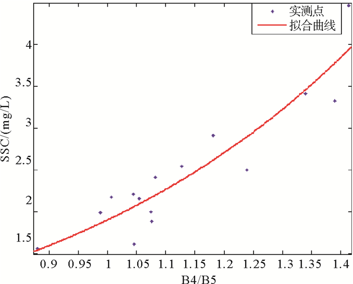
本研究选择与野外时间准同步的六景Landsat 8数据在研究区中覆盖的17个采样点数据用作模型的构建。模型依然采用对泥沙浓度较为敏感的红色波段(B4)和减缓大气作用的近红外波段(B5)进行组合,作为反演表层悬浮体模型的遥感参数:L=B4/B5,同时波段比值还消除了部分悬浮体粒径对悬浮体浓度的干扰作用[23]。在去除两个明显错误的站位数据后,利用MATLAB对15个站位的实测数据和所选取的遥感参数分别以线性函数模型、多项式函数模型、指数函数模型及幂指数函数模型等进行统计分析,指数模型相关系数:R2=0.856,均方根误差:RMSE=0.305 9 mg/L;多项式模型相关系数:R2=0.855,RMSE=0.317 5 mg/L;幂指数模型相关系数:R2=0.846,RMSE=0.316 3 mg/L;线性模型相关系数:R2=0.828,RMSE=0.313 4 mg/L;结果表明指数模型的拟合程度最高(图 4),表层悬浮体浓度估算值与实测值对应较好(表 2),平均相对误差为11.31%。水体表层悬浮体浓度S与遥感参数L的定量关系式为:
$$ S = 0.3253 * {{\rm{e}}^{\left( {1.765 * L} \right)}} $$ (2) 表 2 估算数据与实测数据对比Table 2. Comparison between measured and estimate dataSSC/(mg/L) 相对误差/% 估算值 实测值 2.38 2.54 6.45 2.17 1.88 15.28 3.95 4.47 11.67 1.54 1.56 0.98 2.10 2.16 2.56 2.05 1.61 27.7 1.86 1.99 6.66 2.08 2.91 28.4 2.20 2.24 8.53 3.46 3.41 1.6 2.06 2.21 6.58 1.93 2.17 10.92 3.94 3.33 18.2 2.89 2.50 15.6 2.17 2.00 8.5 注:SSC估算值是基于与本次采样时间最近的Landsat 8卫星影像通过本文的比值模型(式(2))估算到的表层泥沙浓度,SSC实测值是2015年6月20—24日采样的实测值,卫星影像是2015年6月16日与6月25日的各三景,相对误差:|SSC估算值-SSC实测值| /SSC实测值*100%。 1.4 SST反演
对Landsat-TM和Landsat 8影像进行预处理,将影像的辐射亮度值转换为表层反射率:
$$ L\left( {{\rm{ʎ}}} \right) = {\rm{Gain}} * {\rm{DN + Bias}} $$ (3) 其中DN值为像元灰度值,Gain和Bias为增益和偏移量。
(1) Landsat-TM SST反演
利用普朗克公式计算亮度温度:
$$ {T_6} = {K_2}/{\rm{ln}}\left[ {{K_1}/{L}\left( {{\rm{ʎ}}} \right) + 1} \right] $$ (4) 其中T6为TM 6的亮度温度,K1=606.76 W· m-2·sr-1·μm-1,K2=1 260.56 k,使用覃志豪等[12]的单窗算法来实现SST反演:
$$ \begin{array}{*{20}{l}} {T = \left\{ {a * \left( {1 - C - D} \right) + \left[ {b * \left( {1 - C - D} \right) + C + D} \right] * {{T}_{\rm{6}}} - {D} * {{T}_{a}}} \right\}/C\Delta \varepsilon } \end{array} $$ (5) 其中a=-67.355 35;b=0.4586 06;C和D是大气透过率和地表辐射率的函数,C=ε*τ;D =(1-τ)*[1+(1-ε)*τ],大气透过率可以在NASA公布的网站查询(http://atmcorr.gsfc.nasa.gov),水体的地表辐射率ε=0.995,Ta为大气平均温度,Ta=16.011+0.926 21*T6。
(2) Landsat 8 SST反演
采用普朗克公式计算亮度温度:
$$ {T_i} = {K_{i, 2}}/\ln \left[ {{K_{i, 1}}/{L_i}\left( {{\rm{ʎ}}} \right) + 1} \right] $$ (6) 其中Ti为Landsat 8第i通道内的亮度温度,对于第10波段:K10, 1=774.89 W·m-2·sr-1·μm-1,K10, 2=1 321.08k;第11波段:K11, 1=480.89 W·m-2·sr-1·μm-1,K11, 2=1 201.14k;在求出TIRS10、11波段亮度温度后,本文采用Jiménez-Muñoz等[13]的劈窗算法反演SST:
$$ \begin{array}{l} {\rm{SST = }}{T_{{\rm{10}}}} + {C_1}\left( {{T_{10}} - {T_{11}}} \right) + {C_2}{\left( {{T_{10}} - {T_{11}}} \right)^2} + \\ {C_0} + \left( {{C_3} + {C_4}\omega } \right)\left( {1 - \varepsilon } \right) + \left( {{C_5} + {C_6}\omega } \right) \end{array} $$ (7) ε =0.5(ε10+ε11),Δε=(ε10-ε11),ω为大气水汽含量,C0=-0.268,C1=1.378,C2=0.183,C3=54.30,C4=-2.238,C5=-129.20,C6=16.4。
2. 表层悬浮体分布特征
2.1 基于Landsat-TM的SSC分布特征
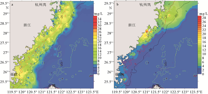
对比2007年2月、7月的SSC分布特征,发现其浓度等值线大致平行海岸线分布,并且呈现出近岸海域水体表层悬浮体浓度明显高于远岸的特点,这是由于贴近岸线流动的浙闽沿岸流携带着大量的悬浮体,以及东北流向的台湾暖流抑制了悬浮体向远海的输运;2月份表层悬浮体浓度明显高于7月份。2月:近岸20 m等深线以浅浓度较高,可达7~25 mg/L,在部分河口附近表层悬浮体浓度可达到30 mg/L;20~50 m等深线以内浓度中等,其浓度范围为3~7 mg/L;50~100 m等深线内浓度较低,为1.3~3 mg/L;100 m等深线以东,随着水深逐渐增大,表层悬浮体浓度逐渐减小,基本为0。7月:近岸20 m等深线以浅海域的表层悬浮体浓度为4~20 mg/L,在部分河口附近水体同样较为浑浊,表层悬浮体浓度可达25 mg/L;20~50 m等深线内的浓度为2.2~4 mg/L;50~100 m等深线内的浓度为1.2~2.2 mg/L。2月份的表层悬浮体高浓度区域相较于7月份发生了明显的扩张,由于在冬季强烈的东北季风作用下,浙闽沿岸流作用强烈,近岸海域表层悬浮体浓度差异最大,而跨过50 m等深线后的海域水体表层悬浮体浓度变化不大。
2.2 基于Landsat-OLI的SSC分布特征
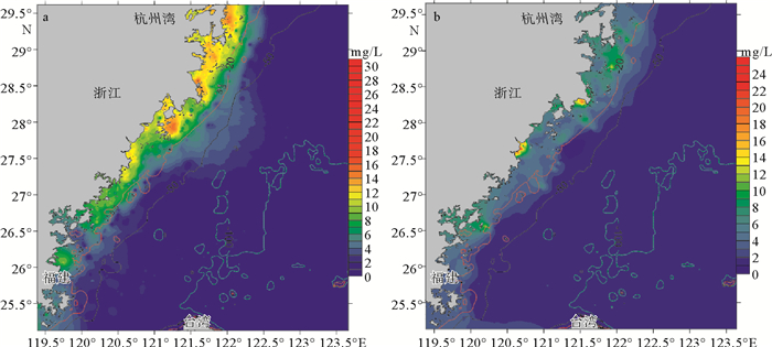
通过对比2014年12月与2015年6月的SSC分布特征(图 6),发现12月份表层悬浮体浓度高于6月份。12月:近岸20m等深线以浅表层悬浮体浓度为12~30 mg/L,在部分河口附近的表层悬浮体浓度较高,达到33 mg/L;20~50 m等深线海域内浓度为6.5~12 mg/L;50~100 m等深线范围内浓度为1.5~6.5 mg/L;跨过100 m等深线后水体清澈。6月:近岸20 m等深线内悬浮体浓度为5~23 mg/L,在杭州湾附近浓度较高,可达26 mg/L;20~50 m等深线海域内为2~5 mg/L;50~100 m等深线范围内为1~2 mg/L;跨过100 m等深线外的浓度也基本为0。在近岸海域,2014年12月与2015年6月的表层悬浮体浓度差异较大,12月表层悬浮体浓度明显高于6月份,这是由于夏季沿岸流作用较弱,以椒江、瓯江、闽江等河流为物源的悬浮体携带距离较近,而冬季水动力较强,同时在风浪作用下使得部分沉积物再悬浮[29],造成了冬季近岸水体表层悬浮体浓度较高。
2.3 SST分布特征
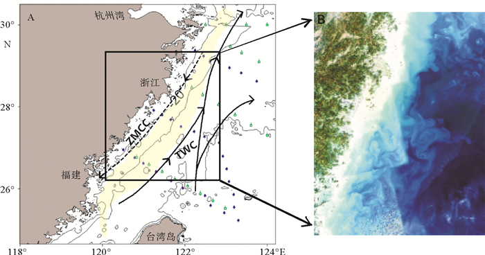
通过2007年2月、7月与2014年12月、2015年6月SST分布特征对比(图 7),发现2007年2月与2014年12月代表的冬季流系特征明显(图 7a、c),呈现出SST近岸低远岸高的特点。在冬季风的作用下,主要在20 m等深线内西南向流动的SST为9℃的浙闽沿岸流与主要在50~100 m等深线内东北向流动的SST为16 ℃的台湾暖流交汇;20~50 m等深线海域为浙闽沿岸流与台湾暖流混合区,随着研究区往南,浙闽沿岸流的影响深度越来越深,在沿岸流与暖流间的相互作用及水深地形的影响下,产生了一系列的涡旋(图 1B),在水深大约为40 m处海域形成较为明显的SST锋面;越过100 m等深线的海域主要是自吕宋海峡流入沿着陆架边缘流动的黑潮分布区,SST较高,可达17 ℃。而2007年7月与2015年6月代表的夏季相对于冬季SST明显升高(图 7b、d),浙闽沿岸流和暖流的特征基本消失,近岸海域SST略高于远岸海域,部分海域可以达到22~23 ℃。
![]() 图 1 浙闽沿岸海域调查站位与冬季流系图(A)及浙闽沿岸真彩色图(B)ZMCC:浙闽沿岸流;TWC:台湾暖流;浅黄色为浙闽泥质区;蓝点为2007年站位,绿点为2015年站位. A据Yuan et al.,2010重新编制; B为Landsat-OLI 4/3/2波段组合,由2014年12月6景影像拼接而成Figure 1. Survey sites and winter flow system in Zhejiang and Fujian coastal area (A) and the true color figure of Zhejiang and Fujian coast area(B) (A Modified from Yuan et al.)ZMCC is the Zhejiang and Fujian coastal current, TWC Taiwan warm current, light yellow area the Zhejiang and Fujian mud area, blue dots the survey sites for 2007, and green dots the survey sites for 2015. B The color image of Zhejiang and Fujian coast area (B is Landsat-OLI 4/3/2 band combination, by six scenes patchwork in December 2014)
图 1 浙闽沿岸海域调查站位与冬季流系图(A)及浙闽沿岸真彩色图(B)ZMCC:浙闽沿岸流;TWC:台湾暖流;浅黄色为浙闽泥质区;蓝点为2007年站位,绿点为2015年站位. A据Yuan et al.,2010重新编制; B为Landsat-OLI 4/3/2波段组合,由2014年12月6景影像拼接而成Figure 1. Survey sites and winter flow system in Zhejiang and Fujian coastal area (A) and the true color figure of Zhejiang and Fujian coast area(B) (A Modified from Yuan et al.)ZMCC is the Zhejiang and Fujian coastal current, TWC Taiwan warm current, light yellow area the Zhejiang and Fujian mud area, blue dots the survey sites for 2007, and green dots the survey sites for 2015. B The color image of Zhejiang and Fujian coast area (B is Landsat-OLI 4/3/2 band combination, by six scenes patchwork in December 2014)2.4 SSC水平分布的控制因素
通过对2007年2月、7月和2014年12月、2015年6月表层悬浮体分布特征比较,发现2月、12月代表的冬季SSC明显高于6月、7月代表的夏季,近岸海域SSC高于远岸海域。根据前人研究[24, 25],浙闽沿岸流的影响深度由杭州湾向南逐渐加深,至闽江口外海域达50 m,再往南逐渐变浅,但主体影响范围还是20 m以浅海域(图 7 a、c),冬季最为强盛,夏季浙闽沿岸流强度减弱,在东南季风的作用下,沿岸向北流动;高温高盐的台湾暖流最多可延伸到30 m等深线处的海域,主要影响范围还是在50~100 m等深线间。冬季浙闽沿岸流携带的悬浮体浓度较高,为10~28 mg/L,台湾暖流携带的SSC范围为1.5~5 mg/L;夏季浙闽沿岸流较弱,其携带的SSC也较低,范围为4~22 mg/L,台湾暖流携带的表层悬浮体浓度范围为1.2~2.3 mg/L。
对比2007年7月份与2015年6月份SSC分布特征,发现2007年7月份SSC分布情况与2015年6月相近,都呈现SSC近岸高、远岸低的特征,杭州湾附近海域与河口水体SSC明显高于其他海域。2007年2月SSC分布特征与2014年12月份趋势大致相同,但2014年12月份的中、高浓度悬浮体海域明显大于2007年,尤其是在台湾暖流控制及台湾暖流与浙闽沿岸流共同影响的海域,2014年12月份大部分海域SSC为3~10 mg/L,而2007年2月份大部分海域SSC范围为1.5~3 mg/L;在浙闽沿岸流控制海域,2007年2月份悬浮体浓度与2014年12月份相近,但2014年高SSC海域面积略大于2007年。这可能是2014年12月所取的卫星影像时刻为落潮,流速较高,而2007年2月份潮位接近最低潮,流速较低;以及2014年12月在研究海域附近受到表层沉积物再悬浮,增大了水体表层悬浮体浓度,而2007年2月份没有受到台风影响。
研究区北部为北邻长江口、西接杭州湾的舟山群岛海域,是杭州湾水体与东海水体交换的主要通道,岛屿众多、水深地形变化剧烈的舟山群岛对研究区北部的流系变化、悬浮体的分布及运移具有显著影响。由于“群岛效应”的存在,舟山群岛海域对来自长江和钱塘江的悬浮体具有“过滤器”和“扩散器”的双重作用,即对较粗颗粒物质进行过滤,加速粗颗粒悬浮体沉降,对较细颗粒物质进行扩散,改变细颗粒悬浮体的分布状态[26]。该海域的水深较浅,在风浪及潮流的作用下,易于发生再悬浮;更多的是受到长江口、杭州湾等河口的陆源物质的输入影响以及苏北浅滩黄河物质输运的影响,SSC较高。舟山群岛海域向东,离岸越来越远,水深越来越深,在风与波浪的搅拌作用下,再悬浮的高浓度悬浮体难以到达水体表层,只存在于水体中、下部[27],因此, 推断舟山群岛东部海域的表层悬浮体来源于舟山群岛海域表层悬浮体的平流输运。只有少量细颗粒悬浮物质可以输运较远的距离,但100 m等深线附近以浅SSC极低,大约为1 mg/L,说明悬浮体向东输运时基本没有超过100 m等深线,这与前人研究[28]悬浮体在东海的输运范围一般不超过100 m等深线,很难跨越过黑潮水系的结果是一致的。
研究区中部海域SSC明显高于其他海域,尤其在强烈的冬季风作用下,SSC较高,这是由于强风浪和潮流对水深小于50 m海域的悬浮体起着非常重要的作用[29],将近岸海域的表层沉积物重新掀起,为表层悬浮体提供了物质来源;而且该区域靠近瓯江、椒江等河流,同样也受到河流陆源物质的输入影响,但更多的是受到浙闽沿岸流携带的长江物质影响,相对于长江陆源物质,输运到研究区中、南部的黄河及老黄河物质基本可以忽略不计[30]。研究区往南即为台湾海峡,该区域SSC相对中部有所降低,大约为13 mg/L,主要是受到闽江河口输入和浙闽沿岸流携带长江物质的影响,以及受到大风作用表层沉积物再悬浮的影响。在台湾海峡靠近台湾岛一侧海域的SSC大约为3 mg/L,沿着台湾暖流向北SSC逐渐降低,由于浙闽沿岸流与台湾暖流之间强烈的锋面及形成的中小尺度涡旋抑制了近岸高浓度悬浮体的水体向外海的输运,只有少量的细颗粒物质通过平流作用到达台湾暖流主控制的区域,通过上图(图 5、6)发现,等深线50 m以深的海域的表层悬浮体还来源于台湾暖流输运台湾海峡中的泥沙,与边昌伟[30]利用数值模拟得到的结果相符。
3. 讨论
浙闽沿岸流与台湾暖流形成的强烈锋面抑制了大部分悬浮物质向外海的扩散,而冬季高温高盐的台湾暖流与低温低盐的浙闽沿岸流的混合,以及中上层悬浮体的跨锋面运输,使得台湾暖流与浙闽沿岸流之间进行少量的物质交换。每年都有大量悬浮物质输运到浙闽沿岸海域,但是大部分悬浮物质都沉积在杭州湾河口附近以及浙闽沿岸北部的舟山群岛周围。冬季,西南流向的浙闽沿岸流携带了大量的悬浮体;夏季,东北向的浙闽沿岸流也携带一部分悬浮体重新输运回到浙闽沿岸北部。同时,由于冬季浙闽沿岸大的风浪和强流的底部剪切应力强烈,部分表层沉积物又被再悬浮。在20 m等深线以浅的海域,SSC最高,主要是受浙闽沿岸流输运长江入海物质作用及大风浪掀起泥沙作用的影响,在研究区近岸的中、南部海域还受到瓯江、闽江等河流影响;在20~50 m等深线内的海域,SSC相对较高,受到浙闽沿岸流和台湾暖流的共同影响;在50 m等深线以深海域,SSC较低,浙闽沿岸流的影响作用微弱,其物质输运的动力为台湾暖流,悬浮体主要来源于浙闽沿岸流携带的长江入海物质、台湾海峡物质以及台湾河流入海物质。由于地形原因,黑潮向陆架爬升并发生变异,部分黑潮水加入到台湾暖流,与台湾暖流近岸分支及浙闽沿岸流共同作用,将细颗粒物质输送至外海,与前人研究结果相似[18, 28, 31-33]。
涡旋泥质区形成的两个基本条件:悬浮体的充足供应及适宜的水动力环境[19]。而浙闽泥质区的形成与浙闽沿岸流与台湾暖流之间的强烈锋面有关,其锋面不仅拦截下大量的来自长江的悬浮体,而且沿岸流与台湾暖流水体交汇过程中产生了一系列涡旋(图 8c),涡旋影响范围内的水动力条件较弱,有利于悬浮体的沉降,从而捕获大量泥沙[33, 34]。在不受地形地势变化的理想条件下,锋面的表层会形成辐聚区,少量的中、上层悬浮物质存在跨锋面输运[35],锋面与悬浮体高浓度边界呈现“X”型,由于跨锋面物质运输的存在使得浙闽泥质区在锋面两侧分布。刘世东认为冬季强锋作用下的环流会促进锋面向岸一层悬浮体沉降,相对使悬浮体在此处富集,对浙闽泥质区的形成有所贡献[27]。
![]() 图 8 SSC梯度分布(a为2014年12月,b为2015年6月;计算方法为:lg(浓度差/距离)锋面强度单位:lg(mg)/(L/km);c为27.4°N、121.4°E海域SST分布)Figure 8. The gradient of SSC(a. in December, 2014, b. in June, 2015; lg means concentration difference/distance, frontal strength units is lg (mg)/L/km); c. SST distribution in sea area of 27.4°N, 121.4°E)
图 8 SSC梯度分布(a为2014年12月,b为2015年6月;计算方法为:lg(浓度差/距离)锋面强度单位:lg(mg)/(L/km);c为27.4°N、121.4°E海域SST分布)Figure 8. The gradient of SSC(a. in December, 2014, b. in June, 2015; lg means concentration difference/distance, frontal strength units is lg (mg)/L/km); c. SST distribution in sea area of 27.4°N, 121.4°E)杨扬等[36]通过对比黄东海SSC次级锋面与东海北部涡旋泥质区,发现悬浮体浓度次级锋面位置与涡旋泥质区位置基本一致,在锋面位置处沉积最为严重,认为次级锋在现代远源泥质区沉积中起重要作用。由于冬季浙闽沿岸流的流幅一般在20 m等深线以浅的海域[37],在20 m等深线附近海域的SSC梯度最大,可以认为是浙闽沿岸悬浮体主锋面,在20 m以浅的沉积可认为是浙闽沿岸流携带悬浮体快速沉降的浙闽沿岸流泥质沉积[36];冬季在研究区等深线40 m附近海域也出现了较为明显的浓度梯度(图 8b),可认为是表层悬浮体浓度次级锋面,与浙闽泥质区位置(20~60 m等深线分布)基本符合,在次级锋面27.4°N、121.4°E处出现了浓度梯度高值,而且东北流向的高温暖流与西南向的低温沿岸流相遇产生了涡旋(图 8c),抑制了悬浮体向外海的输运,加速了悬浮体的沉降,推测在这附近区域泥沙沉降较快,与前人研究利用钻孔资料及浅剖资料得到泥质区厚度最大处位于27°25′N、121°20′E附近的结果大致相符[38]。夏季SSC相对较低,而且浙闽沿岸流与台湾暖流流向基本相同,只有一条断断续续的泥沙锋,无法鉴定次级锋面。对于东北—西南呈条带状分布的浙闽泥质区而言,夏季表层悬浮体浓度较低,沉积物源较缺乏;而冬季表层悬浮体浓度高,可以为该区域的沉积作用提供充沛的物质来源,可初步认为冬季悬浮体及产生的中小尺度锋面涡旋对现代浙闽涡旋泥质区的形成有所贡献。但是由于缺乏必要的实测资料,仅凭表层悬浮体浓度分布以及泥沙悬浮体浓度次锋面的存在无法确定浙闽泥质区现代沉积过程,其过程还有待研究。
4. 结论
利用Landsat卫星遥感反演表层悬浮体浓度及海表温度,较好地反映出浙闽沿岸海域表层悬浮体的分布情况及流系特征,通过对表层悬浮体浓度次级锋面的界定,可以合理地分析出悬浮体的分布情况和运移规律。
(1) 在对Landsat遥感影像数据进行线性函数、多项式函数、指数函数以及幂指数函数模型的参数反演分析之后,本文选取指数函数作为反演模型的效果最好。对Landsat-TM卫星选取(TM3+TM4)/2作为遥感参数进行反演,指数模型反演结果的相关系数为0.971,对Landsat-OLI卫星选取B4/B5作为遥感参数进行反演,指数模型反演结果的相关系数为0.856。
(2) 研究区的SSC分布特征呈现出冬季明显高于夏季,近岸海域明显高于远岸海域的特点;冬季浙闽沿岸流携带SSC范围为10~28 mg/L,台湾暖流为1.5~5 mg/L;夏季浙闽沿岸流携带SSC范围为4~22 mg/L,台湾暖流为1.2~2.3 mg/L。
(3) 冬季等深线40 m附近海域存在较为明显的表层悬浮体浓度次级锋面,而夏季不明显,认为冬季悬浮体及一系列涡旋对现代浙闽涡旋泥质区的形成有所贡献。
-
图 1 浙闽沿岸海域调查站位与冬季流系图(A)及浙闽沿岸真彩色图(B)
ZMCC:浙闽沿岸流;TWC:台湾暖流;浅黄色为浙闽泥质区;蓝点为2007年站位,绿点为2015年站位. A据Yuan et al.,2010重新编制; B为Landsat-OLI 4/3/2波段组合,由2014年12月6景影像拼接而成
Figure 1. Survey sites and winter flow system in Zhejiang and Fujian coastal area (A) and the true color figure of Zhejiang and Fujian coast area(B) (A Modified from Yuan et al.)
ZMCC is the Zhejiang and Fujian coastal current, TWC Taiwan warm current, light yellow area the Zhejiang and Fujian mud area, blue dots the survey sites for 2007, and green dots the survey sites for 2015. B The color image of Zhejiang and Fujian coast area (B is Landsat-OLI 4/3/2 band combination, by six scenes patchwork in December 2014)
图 8 SSC梯度分布
(a为2014年12月,b为2015年6月;计算方法为:lg(浓度差/距离)锋面强度单位:lg(mg)/(L/km);c为27.4°N、121.4°E海域SST分布)
Figure 8. The gradient of SSC
(a. in December, 2014, b. in June, 2015; lg means concentration difference/distance, frontal strength units is lg (mg)/L/km); c. SST distribution in sea area of 27.4°N, 121.4°E)
表 1 影像编号及获取时间信息
Table 1 Image number and time information
TM OLI 编号 获取时间 编号 获取时间 117040-117042 2007-02-11 117040-117042 2015-06-25 118040-118042 2007-02-02 118040-118042 2015-06-16 117040-117042 2007-07-22 117040-117042 2014-12-31 118040-118042 2007-07-28 118040-118042 2014-12-22 表 2 估算数据与实测数据对比
Table 2 Comparison between measured and estimate data
SSC/(mg/L) 相对误差/% 估算值 实测值 2.38 2.54 6.45 2.17 1.88 15.28 3.95 4.47 11.67 1.54 1.56 0.98 2.10 2.16 2.56 2.05 1.61 27.7 1.86 1.99 6.66 2.08 2.91 28.4 2.20 2.24 8.53 3.46 3.41 1.6 2.06 2.21 6.58 1.93 2.17 10.92 3.94 3.33 18.2 2.89 2.50 15.6 2.17 2.00 8.5 注:SSC估算值是基于与本次采样时间最近的Landsat 8卫星影像通过本文的比值模型(式(2))估算到的表层泥沙浓度,SSC实测值是2015年6月20—24日采样的实测值,卫星影像是2015年6月16日与6月25日的各三景,相对误差:|SSC估算值-SSC实测值| /SSC实测值*100%。 -
[1] 刘志国.长江口水体表层泥沙浓度的遥感反演与分析[D].上海: 华东师范大学, 2007. http://cdmd.cnki.com.cn/Article/CDMD-10269-2007082904.htm LIU Zhiguo.Retrieval and Analysis of surface Suspend Sediment Concentration by Remote Sensing in Yangtze River Estuary[D]. Shanghai: East China Normal University, 2007. http://cdmd.cnki.com.cn/Article/CDMD-10269-2007082904.htm
[2] 丛丕福.水色遥感机理与悬浮物的卫星遥感信息识别研究[D].大连海事大学, 2002. http://cdmd.cnki.com.cn/Article/CDMD-10151-2003030835.htm CONG Peifu, Water-color remote sensing principle and retrieval of suspended sediment concentration with satellite remote sensing method[D]. Dalian Maritime University, 2002. http://cdmd.cnki.com.cn/Article/CDMD-10151-2003030835.htm
[3] 胡新礼.水体悬浮泥沙多角度偏振反射特性定量研究[D].东北师范大学, 2005. http://cdmd.cnki.com.cn/article/cdmd-10200-2005073433.htm HU Xinli, The water body suspended silt many angle polarization reflection the quantitative research of the characteristic[D].Northeast Normal University, 2005. http://cdmd.cnki.com.cn/article/cdmd-10200-2005073433.htm
[4] 巩彩兰, 樊伟.海洋水色卫星遥感二类水体反演算法的国际研究进展[J].海洋通报, 2002, 21(2):77-83. doi: 10.3969/j.issn.1001-6392.2002.02.012 GONG Cailan, FAN Wei. Algorithms for case 2 waters of remote sensing of ocean color[J]. Marine Science Bulletin, 2002, 21(2): 77-83. doi: 10.3969/j.issn.1001-6392.2002.02.012
[5] 庞重光, 杨扬, 刘志亮.黄东海悬浮泥沙输运结构及其形成机制[J].泥沙研究, 2010 (3):24-30. http://d.old.wanfangdata.com.cn/Periodical/nsyj201003004 PANG Chongguang, YANG Yang, LIU Zhiliang. Transportation pattern of suspended sediment and its forming mechanism in the Yellow and East China Sea[J].Journal of Sediment Research, 2010(3):24-30. http://d.old.wanfangdata.com.cn/Periodical/nsyj201003004
[6] 孟灵, 屈凡柱, 毕晓丽.二类水体悬浮泥沙遥感反演算法综述[J].浙江海洋学院学报:自然科学版, 2011, 30(5):443-449. http://d.old.wanfangdata.com.cn/Periodical/zjhyxyxb-zr201105014 MENG L, QU F, BI X. A review of retrieval algorithms for suspended sediment concentration by remote sensing[J]. Journal of Zhejiang Ocean University (Natural Science), 2011, 30(5):443-449. http://d.old.wanfangdata.com.cn/Periodical/zjhyxyxb-zr201105014
[7] Gordon H R, Brown O B, Evans R H, et al. A semianalytic radiance model of ocean color[J]. Journal of Geophysical Research Atmospheres, 1988, 93(D9):10909-10924. doi: 10.1029/JD093iD09p10909
[8] TASSAN S. An improved in-water algorithm for the determination of chlorophyll and suspended sediment concentration from Thematic Mapper data in coastal waters[J]. International Journal of Remote Sensing, 1993, 14:1221-1229. doi: 10.1080/01431169308904406
[9] Wang J J, Lu X X, Zhou Y. Retrieval of suspended sediment concentrations in the turbid water of the Upper Yangtze River using Landsat ETM+[J]. Chinese Science Bulletin, 2007, 52(2 Supplement):273-280. http://cn.bing.com/academic/profile?id=d4a731b817d8349e37bad5b680fe69e0&encoded=0&v=paper_preview&mkt=zh-cn
[10] Zhou W, Wang S, Troy Y Z A. Mapping the concentrations of total suspended matter in Lake Taihu, China, using Landsat TM data[J]. International Journal of Remote Sensing, 2008, 27(6):1177-1191. http://www.wanfangdata.com.cn/details/detail.do?_type=perio&id=10.1080/01431160500353825
[11] Cai L N, Tang D L, Li C Y. An investigation of spatial variation of suspended sediment concentration induced by a bay bridge based on Landsat TM and OLI data[J]. Advances in Space Research, 2015, 44(2):293-303. http://www.wanfangdata.com.cn/details/detail.do?_type=perio&id=bcdd51ba73199a1869787f72a3aea0ca
[12] 覃志豪, Karnieli A.用陆地卫星TM6数据演算地表温度的单窗算法[J].地理学报, 2001, 56(4):456-466. http://d.old.wanfangdata.com.cn/Periodical/dlxb200104009 QIN Zhihao, Karnieli A. Mono-window algorithm for retrieving land surface temperature from Landsat TM data and its application to the Israel-Egypt border region[J]. International Journal of Remote Sensing, 2001, 56(4):456-466. http://d.old.wanfangdata.com.cn/Periodical/dlxb200104009
[13] Jiménez-Muñoz J C, Sobrino José A. A generalized single-channel method for retrieving land surface temperature from remote sensing data[J]. Journal of Geophysical Research, 2003, 108(D22):2015-2023. http://cn.bing.com/academic/profile?id=a78e1ac280707c7eeab3f721def6d49e&encoded=0&v=paper_preview&mkt=zh-cn
[14] Jiménez-Muñoz J C, Sobrino J A, Skokovic D, et al. Land surface temperature retrieval methods from Landsat-8 thermal infrared sensor data[J]. IEEE Geoscience & Remote Sensing Letters, 2014, 11(10):1840-1843. http://www.wanfangdata.com.cn/details/detail.do?_type=perio&id=f77c35cd434444e9d0112962236f6bea
[15] Jilan S, Yuqiu P. On the shelf circulation north of Taiwan[J].Acta Oceanologica Sinica, 1987, 6(Supp.Ⅰ): 1-20. http://www.cnki.com.cn/Article/CJFDTotal-SEAE1987S1000.htm
[16] 白虹, 王凡.台湾暖流水和长江冲淡水在32°N断面和PN断面上的分布及其变化[J].海洋科学集刊, 2010, 50(00):11-22. http://www.wanfangdata.com.cn/details/detail.do?_type=perio&id=hykjjk200901002 BAI Hong, WANG Fan. Distribution and variation of Taiwan warm current water and changjiang diluted water along 32°N and PN sections[J].Studia Marina Sinica, 2010, 50(00):11-22] http://www.wanfangdata.com.cn/details/detail.do?_type=perio&id=hykjjk200901002
[17] Qiao F L, Yang Y Z, Lv X G, et al. Coastal upwelling in the East China Sea in winter[J]. Journal of Geophysical Research: Oceans, 2006, 111(C11). http://www.wanfangdata.com.cn/details/detail.do?_type=perio&id=10.1029/2005JC003264
[18] Yuan D, Hsueh Y. Dynamics of the cross-shelf circulation in the Yellow and East China Seas in winter[J]. Deep Sea Research Part Ⅱ Topical Studies in Oceanography, 2010, 57(19-20):1745-1761. doi: 10.1016/j.dsr2.2010.04.002
[19] 陈倩, 黄大吉, 章本照.浙江近海潮汐潮流的数值模拟[J].海洋学报, 2003, 25(5):9-20. doi: 10.3321/j.issn:0253-4193.2003.05.002 CHEN Qian, HUANG Daji, ZHANG Benzhao. Numerical simulation of tide and tidal currents in the seas adjacent to Zhejiang[J]. Acta Oceanologica Sinica, 2003, 25(5): 9-20. doi: 10.3321/j.issn:0253-4193.2003.05.002
[20] 郭志刚, 杨作升, 张东奇, 等.冬、夏季东海北部悬浮体分布及海流对悬浮体输运的阻隔作用[J].海洋学报, 2002, 24(9):71-80. doi: 10.3321/j.issn:0253-4193.2002.05.009 GUO Zhigang, YANG Zuosheng, ZHANG Dongqi, et al. Seasonal distribution of suspended matter in the northern East China Sea and barrier effect of current circulation on its transport[J]. Acta Oceanologica Sinica, 2002, 24(5): 71-80. doi: 10.3321/j.issn:0253-4193.2002.05.009
[21] 郭琳, 陈植华.椒江口—台州湾悬浮泥沙分布特征遥感研究[J].武汉理工大学学报, 2007, 29(5):49-52. doi: 10.3321/j.issn:1671-4431.2007.05.015 GUO Lin, CHEN Zhihua. Remote sensing research on the distribution characteristics of suspended matter in Jiaojiang Estuary and Taizhou Gulf[J]. Journal of Wuhan University of Technology, 2007, 29(5):49-52. doi: 10.3321/j.issn:1671-4431.2007.05.015
[22] 张毅博, 张运林, 査勇, 等.基于Landsat 8影像估算新安江水库总悬浮物浓度[J].环境科学, 2015, 36(1): 56-63. doi: 10.3969/j.issn.1006-4427.2015.01.011 ZHANG Yibo, ZHANG Yunlin, ZHA Yong, et al.Remote sensing estimation of total suspended matter concentration in Xin′anjiang Reservoir using landsat 8 data[J]. Environmental Science, 2015, 36(1): 56-63. doi: 10.3969/j.issn.1006-4427.2015.01.011
[23] 李文红.鄱阳湖水体反射光谱分析及悬浮泥沙定量反演研究[D].江西理工大学, 2014. http://cdmd.cnki.com.cn/Article/CDMD-10407-1015577764.htm LI Wenhong. Analysis of Poyang lake water reflection spectrum and research on the quantitative inversion of suspended sediment[D]. Jiangxi University of Science and Technology, 2014] http://cdmd.cnki.com.cn/Article/CDMD-10407-1015577764.htm
[24] 许金电, 黄奖, 邱云, 等.浙闽沿岸水的空间结构特征及生消过程[J].热带海洋学报, 2015, 36(1):1-7. doi: 10.3969/j.issn.1009-5470.2015.01.001 XU Jindian, HUANG Jiang, QIU Yun, et al. Spatial structure characteristics of Zhejiang and Fujian coastal water and their evolution[J].Journal of Tropical Oceanography, 2015, 36(1):1-7. doi: 10.3969/j.issn.1009-5470.2015.01.001
[25] 曾定勇, 倪晓波, 黄大吉.冬季浙闽沿岸流与台湾暖流在浙南海域的时空变化[J].中国科学:地球科学, 2012, 42(7):1123-1134. http://www.wanfangdata.com.cn/details/detail.do?_type=perio&id=zgkx-cd201207019 ZENG Dingyong, NI Xiaobo, HUANG Daji. Temporal and spatial variability of the ZheMin coastal current and the Taiwan warm current in winter in thesouthern Zhejiang coastal sea[J]. Sci.Sin. Terrae, 2012, 42(7): 1123-1134. http://www.wanfangdata.com.cn/details/detail.do?_type=perio&id=zgkx-cd201207019
[26] 胡日军.舟山群岛海域泥沙运移及动力机制分析[D].中国海洋大学, 2009. http://cdmd.cnki.com.cn/Article/CDMD-10423-2009162543.htm HU Rijun. Sediment transport and dynamic mechanism in the Zhoushan Archipelago sea area [D]. Ocean University of China, 2009. http://cdmd.cnki.com.cn/Article/CDMD-10423-2009162543.htm
[27] Liu S, Qiao L, Li G, et al. Distribution and cross-front transport of suspended particulate matter over the inner shelf of the east China sea[J]. Continental Shelf Research, 2015, 107:92-102. doi: 10.1016/j.csr.2015.07.013
[28] 孙效功, 方明, 黄伟.黄、东海陆架区悬浮体输运的时空变化规律[J].海洋与湖沼, 2000, 31(6):581-587. doi: 10.3321/j.issn:0029-814X.2000.06.001 SUN Xiaogong, FANG Ming, HUANG Wei. Spatial and temporal variations in suspended particulate matter transport on the Yellow and East China Sea shelf [J]. Oceanologia et Limnologia Sinica, 2000, 31(6): 581-587. doi: 10.3321/j.issn:0029-814X.2000.06.001
[29] 王文娟.东中国海表层悬浮体分布的遥感反演及输运机制研究[D].中国海洋大学, 2008. http://cdmd.cnki.com.cn/Article/CDMD-10423-2008174808.htm WANG Wenjuan. Study on the suspended matter's distribution from remote sensing retrieval and its movement mechanisms in the surface layer of the East China Seas[D].Ocean University of China, 2008. http://cdmd.cnki.com.cn/Article/CDMD-10423-2008174808.htm
[30] 边昌伟.中国近岸泥沙在渤海、黄海和东海的输运[D].中国`海洋大学, 2012. http://cdmd.cnki.com.cn/Article/CDMD-10423-1012505862.htm BIAN Changwei. Chinese coastal sediment transport in the Bohai Sea, Yellow Sea and East China Sea[D].Ocean University of China, 2012. http://cdmd.cnki.com.cn/Article/CDMD-10423-1012505862.htm
[31] Bian C, Jiang W, Greatbatch R J. An exploratory model study of sediment transport sources and deposits in the Bohai Sea, Yellow Sea, and East China Sea[J]. Journal of Geophysical Research Oceans, 2013, 118(11):5908-5923. doi: 10.1002/2013JC009116
[32] 刘升发, 石学法, 刘焱光, 等.东海内陆架泥质区夏季悬浮体的分布特征及影响因素分析[J].海洋科学进展, 2011, 29(1):37-46. doi: 10.3969/j.issn.1671-6647.2011.01.005 LIU Shengfa, SHI Xuefa, LIU Yangaung, et al. Distributions of suspended matter in the inner-shelf mud area of the East China Sea in summer and their influence factors[J].Advance in Marine Science, 2011, 29(1):37-46. doi: 10.3969/j.issn.1671-6647.2011.01.005
[33] 李广雪, 杨子赓, 刘勇.中国东部海域海底沉积环境成因研究[M].北京:科学出版社, 2005:1-44. LI Guangxue, YANG Zigeng, LIU Yong. The research of the origin of the sea bottom sedimentary environment in China Seas[M]. Beijing: The Science Publishing Company, 2005: 1-44.
[34] Pang C G, Hu D X. Upwelling and sedimentation dynamics Ⅲ: coincidence of upwelling and areas with mud patches in north hemisphere shelf seas[J]. Chinese Journal of Oceanology and Limnology, 2002, 20(2): 101-106. doi: 10.1007/BF02849645
[35] 苏健.跨陆架锋水交换的数值研究[D].中国海洋大学, 2005. http://cdmd.cnki.com.cn/article/cdmd-10423-2005140460.htm SU Jian. A numerical study of cross-front water exchange[D]. Ocean University of China, 2005. http://cdmd.cnki.com.cn/article/cdmd-10423-2005140460.htm
[36] 杨扬, 庞重光.黄东海表层悬沙浓度次级锋面及其季节变化初探[J].泥沙研究, 2012(2):41-46. doi: 10.3969/j.issn.0468-155X.2012.02.007 YANG Yang, PANG Chongguang. Suspended sediment sub-front and its seasonal variability in Yellow and East China Seas[J]. Journal of Sediment Research, 2012(2): 41-46. doi: 10.3969/j.issn.0468-155X.2012.02.007
[37] 鲍献文, 林霄沛, 吴德星, 等.东海陆架环流季节变化的模拟与分析[J].中国海洋大学学报:自然科学版, 2005, 35(3):349-356. http://www.wanfangdata.com.cn/details/detail.do?_type=perio&id=qdhydxxb200503001 BAO Xianwen, LIN Xiaopei, WU Dexing. Simulation and analysis of shelf circulation and its seasonal variability in the East China Sea[J]. Journal of Ocean University of China, 2005, 35(3): 349-356. http://www.wanfangdata.com.cn/details/detail.do?_type=perio&id=qdhydxxb200503001
[38] 石学法, 刘升发, 乔淑卿, 等.东海闽浙沿岸泥质区沉积特征与古环境记录[J].海洋地质与第四纪地质, 2010, 30(4):24-35. http://www.wanfangdata.com.cn/details/detail.do?_type=perio&id=hydzydsjdz201004004 SHI Xuefa, LIU Shengfa, QIAOShuqing, et al. Depositional features and palaeoenvironmental records of the mud deposition in Min-Zhe coastal mud area, East China Sea [J]. Marine Geology and Quaternary Geology, 2010, 30(4):24-35. http://www.wanfangdata.com.cn/details/detail.do?_type=perio&id=hydzydsjdz201004004
-
期刊类型引用(4)
1. 乔璐璐,王祥宇,刘世东,郭锦. 浙闽海域冬季悬沙锋的次中尺度现象. 海洋科学. 2024(07): 11-21 .  百度学术
百度学术
2. 陈嘉星,江迪,张霄宇. 基于动态模态分解的长江口海表温度时空分布特征重构研究. 浙江大学学报(理学版). 2022(01): 76-84 .  百度学术
百度学术
3. 胡吉连,杜晓琴. 舟山海域悬浮体的特征及输运机制. 海洋地质与第四纪地质. 2020(06): 39-48 .  本站查看
本站查看
4. MIN Jianxiong,LI Guangxue,DING Dong,QIAO Lulu,MA Yanyan,YANG Gang,ZHANG Yaqi,ZHANG Lei,LI Shuhao. Temporal-Spatial Variation of Surface Suspended Matter and Controlling Factors in the Inner Shelf of the East China Sea in Winter. Journal of Ocean University of China. 2019(01): 9-19 .  必应学术
必应学术
其他类型引用(2)


 下载:
下载:
